 The
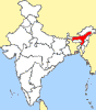
largest of the states in the northeast of India is
Assam whose capital, Guwahati, has an
inspired location on the banks of the River
Brahmaputra. Amidst Assam’s verdant lushness are
two important game sanctuaries, Manas and
Kaziranga, both best known for their population
of one horned Indian rhinoceros, a species that
faced extinction. Much of the rest of the state is
devoted to tea plantation which yield the strong
Assam leaf popular all over the world. The
largest of the states in the northeast of India is
Assam whose capital, Guwahati, has an
inspired location on the banks of the River
Brahmaputra. Amidst Assam’s verdant lushness are
two important game sanctuaries, Manas and
Kaziranga, both best known for their population
of one horned Indian rhinoceros, a species that
faced extinction. Much of the rest of the state is
devoted to tea plantation which yield the strong
Assam leaf popular all over the world.
Guwahati
The
ancient city of Pragjyotishpur or the light of east
is the site of modern Guwahati, the Gateway to North
Eastern India.
 Altitude
: 55 metres. Altitude
: 55 metres.
Temperature (deg C) : Summer- Max.
35, Min. 22; Winter- Max. 26, Min. 10.
Rainfall : 180 cms (from May to
Sept.)
Best Season : October to May.
TRANSPORT
AND COMMUNICATION
- Air
: Indian Airlines connect Guwahati with
Calcutta, Delhi, Bagdogra, Imphal Agartala,
Dibrugarh and Dimapur.
Fare : Calcutta - Guwahati Rs.1157/- (Y),
Rs.1433/- (C), Rs.1594/- (J).
- Rail
: Guwahati is connected by rail with New Delhi,
Calcutta, Bombay, Madras, Trivandrum, Bangalore,
Cochin, Silchar, Tinsukia and Dibrugarh.
Fare : Calcutta - Guwahati Rs.905/-(AC-2A),
Rs.688/-(I), Rs.235/-(II).
- Road
: Guwahati is connected by good motorable roads
with Shillong 103 kms, Kaziranga National Park
217 kms, Manas Wildlife Sanctuary 176 kms,
Dimapur 280 kms, Itanagar 420 kms, Imphal 487
kms, Agartala 599 kms, Aizawal 538 kms, Gangtok
624 kms, Darjeeling 587 kms, Calcutta 1182 kms
and Kohima 342 kms.
- Bus
: Guwahati is connected by regular bus services
with Shillong, Silchar, Dibrugarh, Jorhat,
Tezpur, Siliguri, Sibsagar, Dimapur, Kohima,
Imphal, Aizawal, Itanagar, Barpetta Road and
Cooch Bihar.
PLACES
OF INTEREST
Janardhan
Temple, Navagrah Temple, Umananda Temple,
Bhubaneshwari Devi Temple.
Museums
- Assam
Zoo and Botanical Gardens : 0700 to 1600 hrs
(Sep to March)
- Anthropological
Museum : 1000 to 1600 hrs. Closed on University
Holidays
- Assam
Forest Museum : 1000 to 1600 hrs (Mon to Fri),
1000 to 1300 hrs (Sat)
- Cottage
Industries Museum.
- Museum
of Animal Husbandry and Vaterinary Science
- Assam
State Museum : 1000 to 1630 hrs (Tue to Sat),
0800 to 1200 hrs (Sun)
- Dept.
of Historical & Antiquarium Research : 1000
to 1600 hrs. Sun Closed.
EXCURSIONS
Haplong
(Hill Station) 355 kms; Jatinga (Famous for bird
mystry near Haplong) 364 kms; Hajo 32 kms;
Kamakhya Temple 10 kms; Basistha Ashram 12 kms;
Sualkuch 32 km; Chandubi Lake 64 km; Orang 150 km;
Darrang 100 km; Bhairakunda 137 km; Batadrawa 134
kms; Barpeta 137 kms; Tezpur 181 kms; Bhalukpung 250
kms; Dibrugarh; Digboi; Jorhat; Majuli.
INFORMATION
CENTRES
1)
Government Of India Tourist Office, B.K.Kakati Road,
Ulubari, Guwahati 781 007. Tel: 54-7407.
2) Directorate Of Tourism, Government of Assam,
Station Road, Guwahati 781 007. Tel: 52-7102.
3) Assam Government Tourist Office, 8 Russel Street,
Calcutta 700 016. Tel: 29-8331.
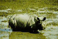 Kaziranga
National Park Kaziranga
National Park
Situated
on the south bank of the Brahmaputra river,
Kaziranga National Park is famous for the stronghold
of the armoured one-horned Indian Rhinocerous. The
Sanctuary provides unique setting for a sight of its
best known wild life including birds.
GENERAL
INFORMATION
Area
of the Park : 430 sq. kms.
Temperature (deg C): Summer-
Max.35, Min.18.3; Winter- Max.24, Min.7.2.
Rainfall : Heavy in Summer (2300
mms).
Best Season : November to March.
Closed Season : Mid-April to
Mid-October.
Languages spoken : Assamese,
Bengali, Hindi, English.
TRANSPORT
AND COMMUNICATION
- Air
: Nearest airport Jorhat (96 kms) is connected
by Indian Airlines flights with Calcutta which
in turn is connected with other cities in India.
Fare: Calcutta - Jorhat (Thursday & Sunday)
Rs.1956 (Y).
- Rail:
Nearest railway station Furkating (75 kms from
Kaziranga) on the metre guage line is directly
connected to Guwahati which in turn is connected
with the other major cities in India.
Fare (approx): Calcutta - Furkating (via
Guwahati) Rs.1175 (AC-2A), Rs.925 (I), Rs.300
(II).
- Road:
Kaziranga (Kohora) to Guwahati 217 km, Jorhat 96
km, Furkating 75 kms.
- Bus
: The Assam Road Transport Corporation runs
regular buses from Guwahati, Jorhat, Furkating
which stop at Kohora 5 kms outside the Park and
where the accommodation is located. Long
distance night coaches run by private operators
from Guwahati and Jorhat also stop here on
request. The Tourist Department, Kaziranga
Forest Lodge, has a reservation quota of 10
seats on the Kaziranga Express from Golaghat to
Guwahati.
- Local
Transport: Taxis available.
SIGHTSEEING
IN THE PARK
Charges
inside the Park
1.
Elephant Charges (per seat) Rs.75 (adult), Rs.50
(child).
2. Vehicle Charges Jeep/Car Mini Bus Bus Toll Fee
(per vehicle) Rs.75 Rs.100 Rs.125 View Fee (per
person) Rs.10 Rs.10 Rs.10
3. Camera Charges Amateur Professional Still without
Telelence Rs.15 -- Still with Telelence Rs.40 Rs.150
Movie (8 mms) Rs.75 -- Movie (10 mms) Rs.200 Rs.750
Video Camera Rs.400 Rs.1500 Movie Camera (35 mms) --
Rs.1500
NOTE:
Toll Fee, View Fee, Elephant Charge & Camera
Fees are payable at Range Forest Office, Kohora,
Kaziranga National Park.
VERY
IMPORTANT
It
is essential for visitors to take a Forest
Department guide with them if they are going by car
or jeep, so that he can both direct the vehicle and
also sight wildlife for the visitors.
HOURS
TO VISIT THE PARK
On
Elephant Back: 0500 to 0600 hrs, 0630 to 0730 hrs
and 1530 to 1630 hrs.
By Road : 0800 to 1100 hrs and 1400 to 1630 hrs.
ROAD
ROUTES FOR VISITING THE PARK
Kaziranga
Range: Kohora, Daflang, Foliamare.
Western Range : Baguri, Monabeel, Bimoli,
Kanchanjuri.
Eastern Range : Agoratoli, Sohola, Rangamatia.
OBSERVATION
TOWERS
These
are located at Sohola, Mihimukh, Kathpara, Foliamare
and Harmoti.
TOURIST
INFORMATION
1)
Government of India Tourist Office, B.K. Kakati
Road, Ulubari, Guwahati- 781 007. Tel: 54-7407.
2) Director of Tourism, Government of Assam,
Ulubari, Guwahati- 781 007. Tel: 52-7102.
3) Kaziranga Wild Life Sanctuary, P.O.Kaziranga- 785
109, Assam. Tel: 23 (Kaziranga exchange).
4) Assam Government Tourist Office, 8 Russel Street,
Sibsagar
Sibsagar
was the capital of the Ahom Kings who ruled Assam
before the advent of the British. The town is build
round the Sibsagar tank, dug over 200 years ago. The
tank is above town level although situated in the
heart of the town. On its banks are located some of
the famous temples of Sibsagar. The Shiva temple,
constructed in the year 1734 is believed to be the
highest Hindu temple in India.
How
To Get There :
- Air
: The nearest airport is at Rewriah, Jorhat (55
kms away) connected by Indian Airlines with
Calcutta, Guwahati and Tezpur.
- Rail
: The nearest railhead is Simaluguri (16 kms
away) on main N.F. Railways.
- Road
: Sibsagar is connected by road to most of the
important places in Assam.
Some distances are :
Guwahati - 369 kms
Kaziranga - 152 kms
Jorhat - 55 kms
Nowgong - 249 kms
Dibrugarh - 76 kms
Tinsukia - 114 kms
What
To See
Sibsagar
Tank and Temples :The tank comprising 120
acres of water, dug ever 200 years age, is above
town level although situated down town. fed by
natural springs, the tank is surrounded by deep
ditches and earthen moats. Three temples are built
on itsbanks - Siva temple, Vishnu temple and Devidol
temple.
Talatal
Ghar : Built in 1699 by king Rudra Singha
about 6 kms from Sibsagar it is an underground
garrison having three stories the lowest connected
with Dikhow river by tunnel.
Kereng
Ghar :9 kms from Sibsagar, this is a seven
storied castle-four above and three below the ground
containing two underground pathways to Dikhow river
and Garden palace.
Rang
Ghar :The Ahom Kings watched elephant
fights and other sporting events from this two-
storied oval-shaped pavilion built by king Pramutta
singha.
Joysagar
Tank and Temple : Historical records reveal
that the tank was constructed in 45 days at Rangpur
in 1697. The tank stands on the area of 318 acres
half of which is under water and on its banks stand
the Jeydol (Vishnu) temple, Shiva temple and Devi
Ghar and Ghanashyam (Nati Gosain) temple.
Gaurisagar
Group : 16 kms south of Sibsagar on the
Assam Trunk Road, Gaurisagar is one of the
historical tanks constructed by Queen Phuleswari in
the year 1723. This springfed tanks is 150 acres
under water and on its banks stand three temples
dedicated to Devi, Shiva and Vishnu.
Gargaon
Palace : The principal town of the Ahom
Kings, constructed by the 15th Ahom King Suklemnung
in 1540 lies in 13 kms east of Sibsagar. The present
seven storied palace was built by King Rajesshar
Singha in about 1762. All the underground stories
and passages were blocked by the East India Company.
The magazine made of bricks is within the palace
compound and further eastward are two old stone
bridges constructed by King Gadadhar Singha.
Charaideo
: 28 kms east of Sibsagar, was the original
capital of the Ahom Kings built by Sukhapa the
founder of the dynasty in about 1229. Charaideo is
famous for its numerous maidams (vaults) of the
kings and members of the royal family resembling the
pyramids of egypt. Most of them were build of stones
and bricks and are in ruins now.
Other
Places : A great number of old Sastras of
the Vaishava cult Muslim Dargahs, Budhist and Sakta
shrines are to be found around Sibsagar, Besides,
there are more than 500 tanks, vaults, earthen forts
and castles belonging to the Ahom, Manipuri, Jaintia
Shan and Kachari kings in this sub-Division.
Excursions
:
Jorhat
(55 kms.)
Itinerary is famous for its sprawling tea gardens.
It is the nerve centre of tea industry. It has the
world reknowned Teklai Experimental Centre.Research
is carried out to find new varieties of tea and also
therapeutic effected of green tea. Regional Research
Laboratory which is situated here conducts
investigation on plants, herbs and seil. There are
also other organisations such as Assam Agricultural
University, Technical School etc. From Jorhat, one
may visit majuli, the largest island on the
Brahmaputna. In Majuli, there are numerous satras or
monasteries. 60 kms aways from Jorhat, lies Nambar
Foprest reserve which is famous for being a
rejuvenating hot spring. Further 90 kms down, one
comes across Dimapur (in Nagaland), once the seat of
Cachar Kingdom.
Dibrugarh
(76 kms)
It is an upcoming major trading centre and a lovely
river side town in Upper Assam. This is the place
where the mighty river Brahmaputra is at its
majestic best.
Miscellaneous
Information :
Banks
: State Bank of India, United Bank of India, Central
Bank of India etc.
Clubs : Lions Club
Information Centre : District
Information and Public Relation Officer.
Haflong
At
680 metres above sea level, in the lush hilly
terrain lies this lovely lakeside resort which is
Assam's only hill station. It is the headquarters of
North Cachar Hills District and is situated at a
distance of 355 kms from Guwahati. Haflong is the
name of variety of orchids, one of them being the
rare Blue Vanda.
General
Information :
- Air
:Nearest airport is Dimapur (266 kms), Jorhat
(364 kms) Gguwahati (355 kms). All there
connected by Indian Airlines with Calcutta.
- Rail
: Haflong is connected by North Erontier Railway
from Guwahati via Lumding.
- Road
: Itinerary is connected by road to important
places. The distance to some important places
are :
Guwahati - 355 kms.
Diphu - 170 kms
Dimapur - 266 kms
Jorhat - 364 kms
Newgong - 309 kms
Golaghat - 335 kms
Assam State Transport Corporation Buses connect
most of these places with Haflong.
What
To See
Haflong
Lake : Situated in the heart of the hill
station it is a picturesque area.
Jatinga
: 9 kms away, this village has attracted
orinthologists from all over the world to unreveal
the mystery of the flocks of little migratory birds
crashing to death on still dark nights. The
phenomenon is attributed by scientists to the
sensitivity of these birds to infra red emissions of
the torches borne by the villages during the nights.
An elevated watch tower provides an opportunity to
see this bird mystery.
Maibong
: 47 kms away from Haflong, on the banks of river
Mahur lies the ruins of the once flourishing capital
of the Dimasa Kachari Kingdom. A stone house and
temple of Kachari kings can be seen at Maibong.
Umrangsu
: 115 kms away from Haflong by road, the biggest
hydel plant under North East Electric Power
Corporation (NEEPCO) has come up with dams across
the river Kopili, a tributery of the Brahmaputra.
Near Umrangsu, there is a hot water spring
(Garampani) which is believed to possess medicinal
properties.
Miscellaneous
Information
For
Tourist Information :-
1. Tourist Information Officer, Haflong PO :
Haflong, District - N.C.Hills, Tel : 268.
2. Directorate of Tourism, Assam, Station Road,
Guwahati 781001, Tel - 27102/31022
Tourist Information Officer, Station Road, Guwahati
781001, Tel : 24475
3. Tourist Information Officer, Assam, 8 Russel
Street, Calcutta - 71.
4. Tourist Information Officer, B-1, Baba Kharak
Singh Marg, New Delhi - 110001 Tel : 325897Haflong,
N.C.Hills Tel : 268
|