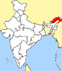
  Right
at the top of north-eastern India, crowning its six
clustered sisters like a protective helmet, is Arunachal
Pradesh, the `Land of the Dawn-lit- Mountains.' This is
the first Indian soil to greet the morning sun. Dawn first
illuminates Arunachal's border with China: a long border
which stretches all the way from its east,
over to its northern boundaries and down to its north-
western edge where it merges with Tibet. To its west is
Bhutan and on its southern end it touches Assam,
Nagaland and Burma before sweeping up to China. Right
at the top of north-eastern India, crowning its six
clustered sisters like a protective helmet, is Arunachal
Pradesh, the `Land of the Dawn-lit- Mountains.' This is
the first Indian soil to greet the morning sun. Dawn first
illuminates Arunachal's border with China: a long border
which stretches all the way from its east,
over to its northern boundaries and down to its north-
western edge where it merges with Tibet. To its west is
Bhutan and on its southern end it touches Assam,
Nagaland and Burma before sweeping up to China.
GENERAL
INFORMATION
| Altitude: |
Naharlagun
- 200 metres |
Itanagar
- 750 metres. |
| Climate
(Degree C.): |
Summer
- Max. 40, Min. 18 |
Winter
- Max. 12, Min. 5. |
| Rainfall: |
266
cms |
266
cms |
| Best
Season: |
October
to April. |
| Clothing: |
Summer
- Cottons; Winter - Woollens. |
| Languages
spoken: |
Indigenous
languages, Hindi, Assamese, Bengali &
English. |
How
to get there
- Air
: The nearest airport is Lilabari (North Lakhimpur) in
Assam, 57 kms from Naharlagun and 67 kms from
Itanagar, served by Vayudoot. Indian Airlines operates
direct flight from Calcutta to Tezpur ( 216 kms from
Itanagar ) on Wednesday, Friday and Sunday.
- Rail:
The nearest railway station is Harmuty (near
Banderdewa check gate) only 23 km from Naharlagun
& 33 km from Itanagar. However nearest convenient
railhead is North Lakhimpur in Assam, 50 km from
Naharlagun & 60 km from Itanagar. Stations are
served by No.9 and No.10 Arunachal Fast Passenger
Trains and other local services.
- Road:
(DISTANCE BETWEEN ITANAGAR AND NAHARLAGUN IS ONLY 10
KMS)
Itanagar
is connected by road to: GUWAHATI- 381 km (Gohpur 79
-Ballipara 110 -Mission Charali 17 -Orang 53 -Baihata
Charali 90 -Guwahati 32), SHILLONG- 481 km ( Guwahati
381 -Shillong 100 ), AGARTALA- 980 km (Shillong 481
-Badarpur 211 -Agartala 288), AIZAWL- 901 km (Badarpur
692 -Silchar 29 -Aizawl 180), KOHIMA- 350 km (North
Lakhimpur 73 -Jorhat 69 -Dimapur 134 -Kohima 74),
IMPHAL- 495 km (Kohima 350 -Imphal 145).
(ITANAGAR IS 1,539 KMS FROM CALCUTTA)
- Bus
: Arunachal Pradesh State Transport Corpn. operates
regular bus-services to various Places in Arunachal
Pradesh and its neighbouring states.
Fares from Itanagar : To Guwahati- Rs.80 (day
service), Rs.90-100 (night service), Shillong- Rs.120
(night), Namsai- Rs.145 (night), Miao- Rs.135 (night),
Tinsukia- Rs.140 (night), Dibrugarh- Rs.130 (night).
(Fares from Naharlagun to the above places : Rs. 5
less than the above fares).
Private coach operators viz. Blue Hills Travels
P.Ltd., Network Travels, Green Valley Travels and Blue
Night Travels operate their services in different
routes touching Itanagar.
- Local
transport: A very few number un-metred
tourist taxi/auto are available. Tourist deluxe buses
for group tourist can be hired from the Director,
Department of Tourism, Govt. of Arunachal Pradesh,
Naharlagun, Tel.: 4371, 4115. A few other transport
agencies in town rent out tourist cars and coaches.
Cycle rickshaws are the most common local transport in
Naharlagun.
Taxi charges : Rs.150 + fuel charges between
Naharlagun and Itanagar or Rs.30 per seat (6 persons).
- Bus:
Direct bus-services are there from North Lakhimpur to
Itanagar via Naharlagun.
Buses run frequently between Naharlagun & Itanagar
between 0600-1900 hrs.
- Cycle
Rickshaw: Only in Naharlagun. Charges Rs.2 to
8 depending on distances. For sight-seeing: Rs. 300 +
fuel charges for a full - day - sightseeing in and
arround Itanagar / Naharlagun.
WHAT
TO SEE
AT
NAHARLAGUN
Polo
Park:An interesting little botanical garden atop
a ridge overlooking the town. Visitors should notice the
cane thicket: it looks a bit like a palm, with spines on
its stems, but growing as a bush. There is also a small
zoo. Handicrafts Centre run by the Industries Department
offers a good range of shawls, carpets, carved caskets
& the beautiful cane & bamboo work in which the
north-east excels. Behind & to one side of the
showroom, is the workshop where cane is trimmed, cut and
woven by tribal artisans with great skill.
Pachin River: This rivulet providing a fine fishing spot
passes by Naharlagun.
Zoo:
18 kms from Naharlagun and near Banderdewa police check
post. Providing glimpses of uncommon Himalayan fauna.
AT
ITANAGAR
The
Buddhist Temple: A new, but beautiful,
yellow-roofed shrine, it rises in well-maintained grounds
behind a stupa bearing the portrait of a monk. At one side
is a tree planted by His Holiness the Dalai Lama. The
grounds of the temple afford a good view of Itanagar town.
Ganga
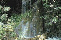
Sekhi Lake: The 6 km drive to the lake from
Itanagar takes visitors on a rugged road through some
superbly primeval jungles : bamboo, orchids massed on tall
trees, tree-ferns are some of the vegetation which can be
identified by the interested traveller. Stopping at the
base of a hill, one has to cross a bamboo bridge floored
with a bamboo mat spanning a culvert. This leads to a
flight of steps cut into the red clay of the hill. At the
top of the ridge one looks down at a serene, green forest
lake which one can cross in a row boat. A beautiful picnic
spot.
Tourist
Information Centre
Government
of India Tourist Office, Sector-C, Naharlagun, Tel.:
371.Director of Information, Public Relations and Tourism,
Government of Arunachal Pradesh, Naharlagun, Tel.: 371.
Government of India Tourist Office, B K Kakati Road,
Ulubari, Guwahati 781007. Tel.: 31381.
Travel
Reservation:
- Air
: Indian Airlines City Office, D K Road, North
Lakhimpur, Tel.: 66 (N L P) Airport, Tel.: 91 (N L P).
- Rail:
Railway out-agency at the state Bus Station in
Naharlagun. They have a small quota on the 155 DN
Tinsukia Mail, 902 DN Trivandrum Mail, 60 DN Kamrup
Express and the N.E. Express. Railway Station in North
Lakhimpur, Tel.: 128 (N L P).
- Bus
: State Transport Bus Station, Tel.: 221 (NLG),
Naharlagun.
Bomdila
Starting
at the airport of Tezpur in Assam. Th road passes through
low wooded slops about 60 kms beyond Tezpur. Anglers or
those who want a brief rest should wait till they
encounter the broad spread of the Bharali river as it
emerges from the mountains into the wooded upper plains.
On the banks of the river, at an elevation of 190 metres
is Tipi, a glass house with over 7,500 orchids. From here
the road is farely steep as it soars up to the small
headquarter of the West Kameng district Bomdila at a
height of over 2530 metres.
It has a tourist lodge, a Craft centre, Apple orchards and
Budhist Gumphas. There are also views of Himalayan
landscapes and Snow clad ranges. Bomdila is a good place
to rest over nights.
How
to raach:
- Air:
Nearest airport is Tezpur(160 kms) served by Indian
Airlines on Tuesday and Saturday.
- Rail:
Bhalukpung (M.G) is the nearest rail station(100 kms).
- Road:
Bus services of APSTC and ASTC are availabe from
Guwahati, Tezpur, Tawang and Itanagar.
Tourist
Spot: ITANAGAR
The
Brahmaputra draws many of its tributaries from the densely
forested mountains of Arunachal; the Siang, the Dibang,
the Lohit and the Noa Dihing are some of the rivers which
drain the rain from some of Arunachal's northern and
eastern ranges and pour them into Brahamputra. The
Subansiri and the Bharali perform similar duties for the
south.
The interpid explorer can paddle up these rivers and
journey...if he has not been deterred by falls and rapids
on the way...as far as China, where the Siang begins, if
he trusts the roads, he will be able to reach the
headquarters of the ten districts, but not very much
further.
No
railway enters Arunachal. But Indian Airlines and Vayudoot
do serve Tezu, Ziro and Pasighat. It's, in other words,
India's largest north-eastern state, and also its
remotest. And this is the beauty and the wonder and the
compelling fascination of unknown Arunachal Pradesh.
But on
the two hour journey from the airport in Lilabari, Assam,
to the capital of Naharlagun(Itanagar), the fascination
grows slowly. Lilabari is a plains town and Naharlagun
gives the impression of a plains town. But the 10 km drive
from the 200 metre high Naharlagun to the new capital in
the hills, Itanagar at 750 metres, is enchanting.
The road
winds through that magical country where tropical
evergreen rain forests meet temperate Himalayan jungles.
Tree ferns spread their greenfronds to great heights;
jungle giants tower into the sky; there are burgeoning
thickets of bamboo; and thick mats of creepers cover
everything with undulating bedspreads of green.
The
visitor should stop at the far side of the bridge that
spans the Pachim River. There is an attractive
village below and to the right of the road leading to
Itanagar. Most of the houses are built at ground level but
at least one is on stilts. Such variations could be the
result of cross-cultural influences between the twenty
major tribes who speak many different languages. According
to one account of some of these varied people: There are
the gently and cultured Monpas of West Kameng who received
Buddhism from Padma Sambhava; the Thongi (Sherdukpens)
whoes chiefs trace their treaty relationships with the
powers in the valley to a thousand years back; the Hrusso
who for thirty generations have patronised Vaishnava
scholars; the proud Bangni-Nishi and the Tagin typifying
the ancient Indian ideal of the honourable warrior; the
Adis and Mishmis who are eager to build academic careers;
the Apatanis with their marvels of wet-rice cultivation;
the Khampti in their magnificent ceremonial robes and the
peaceful, progressive Nocte, Wancho and Tangsa.
The
people of Arunachal are the greatest attraction of this
beautiful land. 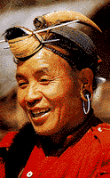 And
even in the capital at Itanagar, the visitor comes across
Nishi warriors wearing their 'bopiah' hornbill caps,
carrying their 'chokh' bearskin bags with their 'oyjo'
knives in their monkey-skin 'burkhey' scabbards. But the
visitor should not be misled by their appearance. And
even in the capital at Itanagar, the visitor comes across
Nishi warriors wearing their 'bopiah' hornbill caps,
carrying their 'chokh' bearskin bags with their 'oyjo'
knives in their monkey-skin 'burkhey' scabbards. But the
visitor should not be misled by their appearance.
As a
community's level of civilisation is judged by its health,
its urge to fulfil its social responsibilities and its
emotional stability, the tribals of Arunachal Pradesh are
highly civilised. According to Dr. Parul Dutta, Director
in the Tribal Culture Research Department , the tribes are
in good health and well-nourished, there are no land
disputes, and when an entire village burns down the whole
community gets together and with great good cheer,
rebuilds it as a community effort. Administrators who have
worked in this state contend that in spite of the fact
that the police have jurisdiction for only 5 kms. around
the District Headquarters, crimes in villages can be
concealed for only three days because the prople are
virtually incapable of telling lies and they have very
clear ideas of justice.
These,
then, are in unspoilt people of Arunachal. And in dealing
with them, the Government of India has taken the words of
Jawaharlal Nehru to heart. India's first Prime Minister
said: "I felt that we should avoid two extreme
courses, one was to treat them as anthropological
specimens for study and the other was to allow them to be
engulfed by masses of India's humanity... We must always
remember that we do not mean to interfere with their way
of life but want to help them live it".
Itanagar
captures the spirit of this desire to minimise the
conflicts that arise when a traditional society is guided
into modernity.
The
capital is a scatter of light, earthquake-proof, woodframe
buildings rising up the slopes of a green hill.
Traditional huts are scattered amongst the more recent
constructions and the residence of the Lt. Governor crowns
one peak while a new Buddhist temple crowns the other.
Between them lie the administrative offices, shops, the
bazar and thatched huts.
It's all
very low-profile and unassuming and even the most
diffident tribal from the remotest village is unlikely to
feel uneasy when he comes to the capital.
Thus,
when the visitor decides to visit this town he should
realise that there is a very good reason for such a
frontier state to have such a frontier town as its
capital: Itanagar.
Itanagar
has been identified with Mayapur, the capital of the 11th
century AD JItri dynasty.
NAMDAPHA
NATIONAL PARK
For the
truly dedicated wilderness and wildlife fan, a visit to
the Namdapha Natioanal Park is a challenging goal. An
unique feature of the park is that it is the only one park
in the world in which four of the great felines are found
viz., the tiger, the leopard, the snow leopard and the
clouded leopard. It is also an ideal for trekking and
hiking.
ENTRY
FORMALITIES
For
Indians:
Indian tourists intended to visit Namdapha
National Park need an Inner Line Permit which can be
obtained from the following authorities:-
- The
Resident Commissioner, Arunachal Bhawan, Kautilya
Marg, Chanakyapuri,New Delhi- 110 001. Tel: 301-3956.
- The
Liaison Officer, Govt. of Arunachal Pradesh, 4-B,
Chowringhee Place, Calcutta- 700 013. Tel: 248-6500.
- The
Liaison Officer, Govt. of Arunachal Pradesh, R.G.
Baruah Road, Guwahati- 781 021. Tel: (0361) 26544.
- The
Liaison Officer, Govt. of Arunachal Pradesh,
Mohanbari, Dibrugarh, Assam. Tel: 398 (Dbrugarh
exchange).
The Inner
Line Permit can also be obtained from The Secretary
(Political), Govt. of Arunachal Pradesh, Itanagar- 791
111or, from The Deputy Commissioner of Changlang district.
For
Foreigner:
Individual
foreigner visiting Arunachal Pradesh require Restricted
Area Permit from the Ministry of Home Affairs, Govt.of
India (F-1), Lok Nayak Bhawan, Khan Market, New Delhi- 110
001. Tel: 619709. Group tourists consisting of at least 4
(four) members can obtain the R.A.P from
- All
F.R.R.O at Calcutta, Delhi, Bombay, Madras;
- Chief
Immigration Officer, Madras;
- The
Commissioner Home, Govt. of Arunachal Pradesh,
Itanagar- 791 111.
GENERAL
INFORMATION
Area
of the park :
Altitude : 200 metres to 4500 metres.
Temperature (deg C): Summer- Max. , Min.
; Winter- Max. , Min.
Clothings : Summer- cottons, Winter-
woollen.
Languages spoken : Tangsa, Singpho,
Assamese, Hindi, English.
Best season : October to April.
HOW
TO GET THERE
- Air
: Nearest airport Dibrugarh (140 kms) is connected
with Calcutta by Indian Airlines as well as pvt.
airlines.
Fare: Calcutta - Dibrugarh Rs.2865 (J), Rs.2065 (Y).
- Rail:
Nearest railway station Margherita is connected by
local passenger train with Tinsukia which in turn is
connected with major cities of India.
Fare (Approx): Calcutta - Margherita (via
Guwahati-Tinsukia) Rs.1025 (I) Rs.315 (II).
- Road:
Good motorable roads connect Miao (entry point of the
park) to Dibrugarh (140 kms), Tezu (182 kms), Sibsagar
(199 kms), Guwahati (561 kms) etc.
TOURIST
INFORMATION
1)
Assistant Director (Tourism), O/o the D.I.P.R., Govt. of
Arunachal Pradesh, Naharlagun, Tel: (03781) 44115.
2) Govt. of India Tourist Office, Sector- C, Naharlagun-
791 110. Tel: (03781) 44328.
|