 Himachal
Pradesh is a tiny hill state whose pleasant summers make
it a popular holiday resort. The Raj still lingers in
Shimla, the state capital and former summer capital
during British rule. Kullu-Manali are neighbouring
resorts, surrounded by pine covered hills and lush
meadows. Himachal has, in addition to popular resort
towns, a series of secluded hill retreats ideal for
interested anglers, trekkers and those wanting a quiet
getaway. Many of these include: from Shimla – Mashobra,
Kufri, Naldehra; those around Kullu-Manali include
Manikaran, Naggar and Brighu Lake; the barely accessible
valleys of Lahaul and Spiti are a trekker’s delight. Himachal
Pradesh is a tiny hill state whose pleasant summers make
it a popular holiday resort. The Raj still lingers in
Shimla, the state capital and former summer capital
during British rule. Kullu-Manali are neighbouring
resorts, surrounded by pine covered hills and lush
meadows. Himachal has, in addition to popular resort
towns, a series of secluded hill retreats ideal for
interested anglers, trekkers and those wanting a quiet
getaway. Many of these include: from Shimla – Mashobra,
Kufri, Naldehra; those around Kullu-Manali include
Manikaran, Naggar and Brighu Lake; the barely accessible
valleys of Lahaul and Spiti are a trekker’s delight.
 Shimla Shimla
Situated
in the north-west Himalayas, Shimla is the capital of
Himachal Pradesh. Spread across 12 kms along a ridge that
overlooks terraced hillsides and cultivations, Shimla is
magnificently robed in dense forests of oak and pine, fur
and rhododendron, and it is best to travel here on the
slow train from Kalka. Shimla also is a convenient base
for variety of adventure sports such as Skiing, Trekking,
Fishing and Golfing etc.
GENERAL
INFORMATION
Area
: 18 sq. km.
Altitude : 2,213 metres.
Temperature (deg C): Summer- Max.27,
Min.14.5; Winter- Max.16.5, Min.5.2.
Clothings : Summer - Light woollens,
Winter - Heavy woollens.
Best Season : April to Mid-July,
Mid-September to Mid-November.
Languages Spoken : Pahari (Local
Dialect), Hindi, English.
TRANSPORT
AND COMMUNICATION
- Air
: Vayudoot services connect Jubbor-Hatti (23 kms from
Shimla) with Kullu, Chandigarh and Delhi. Delhi is in
turn connected with Culcutta by Indian Airlines
flights. Jagson Airlines has also flights from Delhi
to Shimla.
Fare: Calcutta-Delhi Rs.4797 (J), Rs.3445 (Y).
- Rail:
Shimla is connected by a narrow guage railway line
with Kalka (90 kms) which in turn is connected with
the major cities in India.
Fare(approx): Calcutta-Shimla Rs.1406 (AC-2A), Rs.1105
(I), Rs.334 (II).
- Road:
Regular bus services connect Shimla with Chandigarh
117 kms, Kullu 220 kms, Manali 260 kms, Delhi 343 kms,
Mandi 150 kms, Pathankot 380 kms, Ambala 151 kms,
Chail 43 kms, Dehradun 240 kms etc.
- Local
Transport: Taxis are available here as the
main local transport.
Fare : Basic rate for outstation is Rs.6/- per kms
with a minimum charge of 150 kms per day plus Rs.80 as
night halt charge.
CONDUCTED
TOURS
HPTDC
conducts the following tours from the Tourist Office, The
Mall, Shimla.
Places
Covered Timings Fare
Tour
No. I
Wild Flower Hall, Kufri, Indira 0900 hrs Rs.90/- by bus
Holiday Home Fagu, Mashobra, to Rs.405/- by car
Craignano Fruit Research Station 1700 hrs and Naldera.
Tour
No. II
Fagu, Theog, Maitana, Narkhanda 0900 hrs Rs.90/- by bus
(Only Wed, Fri and Sun) to Rs.545/- by car 1700 hrs
Tour
No. III
Chail, Kufri, Indira Holiday Home 0900 hrs Rs.90/- by bus
Kiari Bungalow to Rs.500/- by car (Only Mon, Thu and Sat)
1700 hrs
PLACES
OF INTEREST
Jakhoo
Hill- 2 kms, Glen- 4 kms, Summer Hill- 5 kms, Chadwick
Falls- 7 kms, Zoo- 4 kms, Navbahar- 4 kms, Sanket Mochen-
5 kms, Tara Devi Temple- 8 kms, Institute of Advance
Studies- 4 kms, Aviary at Old Raj Bhavan- 1 km, Tibetan
Monastery- 8 kms, Dhengu Mata Temple- 5 kms.
EXCURSIONS
- Naldera
: 23 kms. Acco:- Hotel Golf Glade (HPTDC), Tel: 8265;
- Tattapani
: 43 kms. Acco:- Tourist Bungalow (HPTDC);
- Wildflower
Hall : 13 kms. Acco: Hotel Wildflower Hall (HPTDC),
Tel.8212.
- Mashobra
: 13 kms.
- Craignano
: 16 kms.
- Fruit
Research Station: 08 kms.
- Kufri
: 16 kms. Acco: Kufri Holiday Resort, Tel. 8341-44.
- Indira
Holiday Home : 18 kms.
- Chail
: 43 kms. Acco: Chail Palace Hotel (HPTDC), Tel. 43,
37.
- Barog
: 55 kms. Acco: Hotel Pinewood (HPTDC), Tel.2325.
- Kasauli
: 77 kms. Acco: Hotel Ross Common (HPTDC), Tel. 5.
- Kiarighat
: 23 kms. Acco: Tourist Inn (HPTDC).
- Solan
: 48 kms.
- Bon
Monastery Uohghat : 61 kms.
- Fagu :
22 kms.
- Narkanda
: 64 kms. Acco: Hotel Himview (HPTDC).
- Kotgarh
: 82 kms.
SPORTING
ACTIVITIES
- Golfing
: Nine hole Golf Course at Naldhera, 23 km from
Shimla.
- Fishing
: Trout fishing is available at Rohru 110 km from
Shimla and at Seema 1 km from Rohru. Mahaseer fishing
is available at Tattapani 43 km from Shimla. Licence
fee Rs.10 per day per person. Licencing Authority :-
Assistant Director-Fisheries, Khaline, Shimla (H.P.),
Tel : 4732 & 6985.
- Skiing
: The skiing season generally commences in the first
fortnight of January and continues till Mid-March
depending upon snow conditions. HPTDC organises ski
courses of 7 days and 15 days duration at Narkhanda
(65 km) every year. The facilities for the
participants include boarding, lodging and equipment.
Cost for 7 days Rs. 1500/-, for 15 days Rs. 3000/-
- Trekking
: The Shimla-Kinnaur region offers some exciting
trekking opportunities viz.
a) Shimla to Kulu via Jaloni Pass (66 kms).
b) Shimla to Kulu via Bashleo Pass (56 kms).
c) Sarahen to Sangla (106 kms).
INFORMATION
CENTRE
1.Director,
Department of Tourism & Civil Aviation, Govt. of
Himachal Pradesh, Shimla- 171 001, Tel: (0177) 203346,
3517. Fax: 203346.
2.Tourist Information Centre, Government of Himachal
Pradesh, Shimla- 171 001, Tel: (0177) 4589.
3.Himachal Pradesh Tourism Development Corporation Limited
(H.P.T.D.C.), Marketing Office, The Mall, Shimla- 171 001,
Tel: (0177) 78302, 78311. Fax: (0177) 212591.
4.H.P.T.D.C., Rita Annexe, Shimla- 171 001. Tel: (0177)
3294, 5071, 78277.
Dalhousie
Dalhousie,
nestling in the outer slopes of Dhaulandhar range, is a
excellence hill station. It is known for its bracing
climate and picturesque scenery.
GENERAL
INFORMATION
Area
: 13 sq. km.
Altitude : 2036 metres.
Temperature (deg C): Summer - Max 23.5,
Min 15.5; Winter - Max 10, Min 1.
Clothings : Summer - Light woollens,
Winter - Heavy woollens.
Best Season : April to November.
Languages Spoken : Pahari (Local
Dialect), Hindi, English.
TRANSPORT
AND COMMUNICATION
- Air
: The nearest airports Amritsar (118 kms) & Jammu
(188 kms) are connected to Delhi by Indian Airlines as
well as by Vayudoot flights.
Fare: Calcutta-Delhi Rs.3445 (Y), Rs.4797 (J).
Delhi-Amritsar Rs.1548 (Y). Delhi-Jammu Rs.2066 (Y),
Rs.2865 (J).
- Rail:
The nearest railhead is Pathankot (80 kms) and is
connected to all of the major cities in India.
Fare (approx): Calcutta-Pathankot Rs.1480 (AC-2A),
1230 (I), 329 (II).
- Road:
Regular bus services connect Dalhousie with Amritsar
188 kms, Jalandhar 192 kms, Pathankot 80 kms,
Chamba 56 kms, Manali 402 kms, Delhi 563 kms,
Chandigarh 352 kms, Dharamshala 143 kms, Khajjiar 27
kms, Jammu 188 kms.
- Local
Transport: Taxis and ponies are available.
CONDUCTED
TOURS
(HPTDC conducts the following tours from Dalohousie
complex)
1)
Dalhousie - Pathankot & vice-versa (one way) :
Rs.100/- per seat.
2) Dalhousie to Khajjiar & back : Rs. 60/- per seat.
3) Dalhousie to Chamba & back : Rs.100/- per seat.
PLACES
OF INTEREST AND EXCURSIONS
Panjpulla
(2 kms); Subhash Baoli & Jandri Ghat (1.6 kms); The
Round (4.8 kms); Dainkund (10 kms); Khajjiar (27 kms);
Kalatop Wild Life Sanctuary; Kugti Wild Life Sanctuary (35
kms on foot); Tundah Wild Life Sanctuary (45 kms).
TOURIST
INFORMATION
1)
Himachal Pradesh Tourism, Tourist Information Office,
Dalhousie- 176 304, Tel: 36.
Chamba
Perched
on a flat mountain shelf, the town of Chamba is known for
its ancient temples and Chaugan - a public promenade.
GENERAL
INFORMATION
Area
: 2.4 sq. km.
Altitude : 926 metres.
Temperature(deg C): Summer- Max. 39, Min.
8; Winter- Max. 10, Min. 1.1.
Clothings : Summer- Light woollens,
Winter- Heavy woollens.
Best Season : April to Mid July and Mid
September to December.
Languages Spoken : Pahari (Local
Dialect), Hindi, English.
TRANSPORT
AND COMMUNICATION
- Air
: Nearest airport is Dharamshala connected to Delhi by
Vayudoot services.
Fare: Calcutta- Delhi Rs.4797 (J), Rs.3445 (Y).
- Rail:
Nearest railhead is Pathankot (120 kms) which is
connected to major cities in India.
- Road:
By the State Highway No. 33/35, Chamba is connected to
all parts of the country. Important road distances
are: Amritsar 245 kms, Kangra 180 kms, Pathankot 120
kms, Shimla 422 kms, Manali 470 kms, Dharamshala 180
kms, Dalhousie 56 kms, Khajjiar 30 kms, Mandi 334 kms,
Jammu 229 kms etc.
- Local
Transport: Taxis, Jeeps and buses available.
WHAT
TO SEE
Lakshman
Narayan Temple, Chamunda Temple, Katasan Devi Temple, Bhuj
Sing Museum, Chaugan.
EXCURSIONS
Saral (11
km), Salooni (56 km), Saho (12 km), Badal (22 km),
Bharmaur (69 km), Shakti Devi Temple (40 km), Mindhal (125
km), Khajjiar (30 km). Mani Mahesh: 35 kms from Bharmaur.
The Lake of Mani Mahesh, (3,950 metres), is the highest of
the sacred lakes in Chamba district. It is an important
pilgrim centre and thousands of people every year visit
this sacred lake on the 15th day after Janmastami
(July-August) to take a dip in the water.
Those who
wish to join the pilgrimage may contact :
the Deputy Commissioner at Chamba in advance for transport
and accomodation facilities.
TREKKING
Chamba
provides ample oppurtunities for trekking as it has three
well-definned snow ranges Dhauladhar, Pir Panjal and
Laskar.
Some
trekking routes are:-
- 1.
Chamba - Sarol (8 kms) - Bandal (24 kms) - Chhatrari
(40 kms).
- 2.
Chamba - Tissa (67 kms) - Triala (21 kms) - Strundi
(14 kms) - Bindrabani (18 kms) - Kilar (11 kms),
Kishtwar (or turn east about half way to Kishtwar and
cross the Umasila Park into the Zanskar valley or trek
South East to Keylong).
- 3.
Chamba - Tissa (67 kms) - Triala (21 kms) - Strundi
(14.5 kms), Brindabani (18 kms) - Kilar (11 kms) -
Purthi (29 kms), Ravoli (23 kms) - Tindi (18 kms),
Salguraor (16 kms) - Udeypur (16 kms). It is ten days
trek.
- FISHING:
Mahaseer fishing is permitted in river Ravi and its
tributaries like Siul, Chakki, Dehar, Behral, Salkhad.
For
necessary licence please contact: The Fisheries Officer,
Chamba.
TOURIST
INFORMATION CENTRES
1.
Tourist Information Centre, Himachal Tourism, Hotel
Travati, Tel: 2671.
 Dharamsala Dharamsala
Dharamshala
stands on a spur of the Dhauladhar range amidst
magnificient deodar and pine forests, tea gardens and
beautiful hills. It is also known as 'The Lhasa in India'.
GENERAL
INFORMATION
Area
: 28.81 sq. km.
Altitude : Between 1250 metres and 1982
metres.
Temperature (deg C) : Summer - Max.33,
Min.22; Winter - Max.15, Min. 0.
Clothings : Summer - Light woollens,
Winter - Heavy woollens.
Best Season : April to June and September
to November.
Languages Spoken : Pahari (the local
dialect), Hindi.
TRANSPORT
AND COMMUNICATION
- Air
: The nearest airport, Amritsar (200 kms), is
connected to New Delhi by Indian Airlines.
Fare: Calcutta- Delhi Rs.3445 (Y), Rs.4797 (J). Delhi-
Amritsar Rs.1548 (Y).
- Rail:
The nearest railhead Pathankot (90 kms) is connected
to major cities in India. There is a narrow guage
train from Pathankot to Kangra (18 kms).
- Road:
Direct & regular bus services link Dharamshala
with Chandigarh 239 kms, Delhi 514 kms, Dalhousie 143
kms, Hoshiarpur 128 kms, Jwalamukhi 55 kms, Jammu 197
kms, Kangra 18 kms, Kullu 214 km, Manali 253 km, Mandi
147 km, Nangal 145 kms, Palampur 35 kms Chamba 192 kms
and Shimla 322 kms.
- Local
Transport: Buses and taxis available.
CONDUCTED
TOURS
HPTDC
conducts the following tours from Dharamshala complex.
1) Dharamshala to Badrinath & back via
Palampur-Chamundadri: Rs.100 per seat.
2) Dharamshala to Jwalaji-Chint-Purni and back via Kangra:
Rs.100 per seat.
PLACES
OF INTEREST
MC
leodganj (10 kms); Tibetan Medical & Astro Institute;
Bhagsunath (11 kms); St. John's Church (8 kms); Kunal
Pathri (3 kms); War Memorial (2 kms).
EXCURSIONS
Chirmaya
Topovan (10 km); Dal Lake (11 km); Dharamkot (11 km);
Triund (17 km); Kareri (22 km); Kangra (18 km); Jwalamukhi
(56 km); Nadaun (10 km); Chintpurni (80 km); Masroor (40
km); Trilokpur (41 km); Nurpur (66 km); Sujanpur Tira (80
km); Chamunda Devi Temple (15 km); Palampur (35 km); Pong
Wild life Sanctuary (Kangra); Bassa Wild Life Sanctuary
(Kangra).
Trekking:-
There is a branch of the Mountaineering Institute Manali,
Dharamshala.
Routes:
1. Dharamshala-Dharamkot-Triund-Dharamshala - 34 kms.
2. Dharamshala-Khanyara-Aghanjar-Mahadev-Dharamshala - 16
kms.
3. Dharamshala-Chamunda-Dadh-Dharamshala - 29 kms.
4. Dharamshala-Bhagsunath-Dharamshala - 22 kms.
5. Dharamshala-Kareri Lake-Dharamshala - 35 kms.
TOURIST
INFORMATION CENTRE:
Himachal
Pradesh Tourism Development Corporation, Tourist
Information Office Kotwali Bazaar, Dharamshala, Tel: 3107.
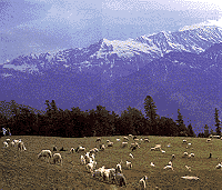
Kulu-Valley.
The
Valley of Gods, as the Kullu Valley has come to be known,
if perhaps the most delightful region in the Western
Himalayas. Situated on the banks of the river Beas, Kullu,
the headquarters of the district, serves as a nerve centre
of the valley and is the starting place for a number of
treks.
GENERAL
INFORMATION:
Area
: 6.68 sq.kms.
Altitude : 1,219 metres.
Climate (deg C): Summer- Max. 30.8, Min.
18.8; Winter- Max. 16.4, Min. 5.2.
Rainfall : 102 cms.
Clothings : Summer- Light woollens,
Winter- Heavy woollens.
Best Season : Mid-March to Mid-November.
TRANSPORT
AND COMMUNICATION
- Air
: The nearest airport Bhuntar (10 kms from Kullu) is
connected by Vayudoot services with Delhi and
Chandigarh. Jagson & Continental Airlines also
operates flights from Delhi to Kullu.
- Rail:
The nearest most convenient railhead is Chandigarh
(272 kms). The other nearest narrow gauge railheads
are Jogindarnagar (166 kms) with a change at Pathankot
and Shimla (240 kms) with a change at Kalka.
- Road:
Kullu is connected by road with Ambala (606 kms),
Chandigarh (556 kms), Delhi (798 kms), Pathankot (278
kms), Shimla (240 kms), Manali (40 kms), Palampur (164
kms), Mandi (70 kms), Kyelang (158 kms), Katrain (21
kms), Rohatang Pass (91 kms), Dharamshala (213 kms),
Dalhousie (334 kms), Chamba (383 kms), Bilaspur (139
kms), Jogindarnagar (166 kms) etc. Regular
bus-services connect Kullu with the above places and
others.
Manali
-
KULLU:
The Valley of Gods as the Kullu Valley has come to be
known is perhaps the most delightful region in the Western
Himalayas. Situated on the banks of the river Beas, Kullu,
the district H.Q., serves as the nerve centre of the
valley and is the starting place for a number of treks.
MANALI:
For a lavish display of natural scenery, it is one of the
principal snow places of the Kullu region. And Manali is
at an altitude of beauty and gateway to Dhauli and Spiti.
GENERAL
INFORMATION:
Manali
Area
: 5.12 sq.kms.
Altitude : 1,926 metres.
Temperature (deg C): Summer- Max. 25,
Min. 12. Winter- Max. 14.5, Min. 2.
Clothings : Summer- Light woollens for
both the places.
Winter- Heavy woollens for both the places.
Best Season : April to Mid-July and Sep.
to Nov. for both the places.
Languages Spoken : Pahari (Local
Dialect), Hindi, English.
STD Code : 01902.
TRANSPORT
AND COMUNICATION
- Air
: The nearest airport Bhuntar (10 kms from Kullu and
50 kms from Manali) is connected by Vayudoot services
with Delhi and Chandigarh. Jagson & Continental
Airlines also operates flights from Delhi to Kullu.
Fare: Calcutta-Delhi Rs.4797 (J), 3445 (Y).
- Rail:
The nearest most convenient railhead is Chandigarh
(397 kms from Kullu and 357 kms from Manali). The
other nearest narrow gauge railheads are Jogindarnagar
(126 kms from Kullu & 166 kms from Manali) with a
change at Pathankot and Shimla (240 kms from Kullu
& 280 kms Manali) with a change at Kalka.
- Road:
Kullu and Manali both the places are on the National
Highway No. 21. Motorable roads and regular bus
services connect Kullu & Manali to most of the
important places in Himachal Pradesh and the
neighbouring states.
Some of the road-distances are:-
| kms |
Ambala |
Chandigarh |
Delhi |
Pathankot |
Shimla |
Palampur |
Dalhousie |
| Kullu- |
606 |
398 |
563 |
278 |
220 |
164 |
334 |
| Manali- |
646 |
357 |
603 |
318 |
260 |
204 |
294 |
| kms |
Chamba |
Keylang |
Bilaspur |
Rohtang
Pass |
Dharamshala |
Jogindarnagar |
| Kullu- |
383 |
158 |
139 |
91 |
213 |
126 |
| Manali- |
343 |
118 |
179 |
51 |
253 |
166 |
Taxi (4
seats): Taxi services are avilable here from one place to
another inand outside of the state. Taxis are available
for local sight seeing at the rate of Rs.450 to Rs.550 per
day.
PLACES
OF INTEREST
Raghunathji
Temple (1 km), Vaishno Devi Temple (4 km), Jagannath
Temple (3 km) Bijli Mahadev Shrine (13 km).
EXCURSIONS
Raison
(16 km), Katrain (20 km), Naggar (28 km), Bajaura (15 km),
Kasol (42 km) Manikaran (45 km), Banjar (58 km), Larji (34
km), Malana, Pulga & Khirganga (16 km & 26
km), Danawar Wildlife Sanctuary (near Manikaran), Khokhan
Wildlife Sanctuary (20 km from Bhuntar), Khaiv Sanctuary
(15 km), Tirthan Sanctuary (10 km from Bunder Gushanini).
CONDUCTED
TOURS
HPTDC
conducts the following tours during season only.
1. Manali-Nehru Kund-Rahla Falls-Marhi-Rohtang
Pass-Manali, Daily from 0900 hours to 1600 hours. Tariff:
Rs.175 per head by luxury coach.
2. Manali-Jagat Sukh-Naggar-Manali Daily from 0900 hours
to 1600 hours. Fare: Rs.100 per head.
3. Manali-Vaishnodevi, Bhutti Weaver's - Parvati Valley -
Kasol - Manali Daily from 0900 hours to 1800 hours. Fare:
Rs.250 per head.
PLACES
OF INTEREST & EXCURSIONS
Vashisht
Bath (3 kms), Hadimba Devi Temple, Tibetan Monastry, Arjun
Gumpha (5 kms), Nehru Kund (5 kms), Jagatsukh (6 kms),
Kothi (12 kms) & Rahla Falls (14 km), Solang Valley
(13 km), Rohtang Pass (51 kms), Keylong Pass (117 kms),
Manali Wildlife Sanctuary (3 kms on foot. HPTDC bungalows
are available here)
Manali-Leh
Road:
There are bus services connecting Manali with Leh via
Keylong during the period July to October/November. It is
a two day journey between Manali and Leh with an overnight
halt at Keylong. There are regular bus services between
Manali and Keylong (117 kms) which takes approximately 7-8
hours. Bus services between Keylong and Leh (390 kms)
largely depend on the weather and road conditions. The
journey takes approximately 18-19 hours. Foreign tourists
are allowed to travel between 15th July and 15th August on
the Leh-Manali road, subject to following conditions.
a) Only groups of foreign tourists whose visits are
arranged by Indian Travel Agents, recognised by the Govt.
of India, are allowed to travel provided the travel agents
representative accompanies the group.
b) Their travel has to be confined to specified modes of
conveyance like jeep matador etc.
c) A police escort by the State government is attached to
the group.
SPORTS
Institute
of Mountaineering & Allied Sports, Manali, Tel: 42.
This institute organises training courses, both basic and
advanced, in hiking, mountaineering, skiing, water sports
and mountain rescues. The complex has hostel facilities
and equipment for trekking/hikingcan be hired from
institute.
FISHING
The Kulu
valley offers ample opportunities for trout fishing in the
river Beas & its larger tributaries. Licences can be
obtained from the Fisheries officer - Katrain.
TREKKING
Kulu-Manali,
together with Lahaul-Spiti, offers possibly the best
trekking opportunities. Some important treks in
Kulu-Manali region:-
- Raison-Malana-Chandrakhan-Raison
(139 kms) - 11 days
- Manali-Bhirug-Rohtang
Pass-Manali (55 kms) - 4 days
- Manali-Chandratal-Keylong
(120 kms) - 10 days
- Manali-Chhikar-Hamta
Pass-Jagatsukh-Manali (55 kms) - 6 days
Trek
& Tour Operators
1. Deputy
Director, Mountaineering & Allied Sports, Manali,
Himachal Pradesh.Phone: 2342, 2206, 2137.
2. Himalayan Adventures Pvt. Ltd., The Mall, Manali- 175,
131 Tel: 182, 104
3. Arohi Travels, The Mall, Manali - 175, 131 Tel: 139.
4. Paramount Skiing Club, Vill.& P.O. Vashisht,
Manali-175 131. Tel:8242,8272
TOURIST
INFORMATION CENTRE
1. HPTDC
Tourist Information office, Manali, Tel: 25, 116
2. Tourist Information Centre, Bhuntar Airport, Bhuntar
3. Tourist Information Office, HPTDC, Dhalpur, Kulu, Tel :
2349
Kinnaur,
Spiti and Lahaul
Located
in the dizzy heights of the Himalayas, with passes that
remain closed for six months, Kinnaur, Spiti and Lahaul
were till now, a forbidden land. Now this area has been
opened for the daring and adventurous who can discover
what had been hidden from the world for centuries. From
the riotous green of the Sangla Valley- filled with
orchards of apricots, peaches, apples and Chilgoza pine
forests, to the magnificent desolation of the Hangrang
Valley, Mother Nature's portrait is everchanging in
Kinnaur. This land lying on the ancient trade route
between India and Tibet, ringed by the majestic mountains
of the Himalayan and Dhauladhar range is a land of plenty.
ENTRY
FORMALITIES
Foreign
nationals can travel with permits issued by
(a) District Magistrate:-
Shimla; Rekong Peo (Kinnaur); Kullu; Keylong (Lahaul);
(b) Sub District Magistrate:- Shimla; Rampur; Kalpa,
Nichar (Kinnaur); Keylong, Udaipur (Lahaul); or
(c) Additional Deputy Commissioner's office:- Pooh
(Kinnaur); Kaza (Lahaul) only when they are traveling in a
group of four(4) or more persons with a predrawn itinerary
through a recognized travel agent. The permits can be
obtained on presenting the following documents,viz. i)
Three passport size photographs, ii) Police verification
from home town or any other equivalent documents like
passport, driving license etc., which can establish the
identification of the applicant. Foreigners are required
to present an itinerary and introduction by a recognized
travel agent. The tourists are advised to get their
documents verified at the check points at
Chitkul,Lippa,Khud (Kinnaur) and Kaza (Spiti).
HOW
TO GET THERE
A)
Kinnaur
- Air
: The nearest airport Shimla is 224 kms from Kalpa (in
Kinnaur).
- Rail:
The nearest railhead Kalka, 314 kms from Kalpa in
Kinnaur, is connected with the major places in India.
- Road:
Kalpa is one of the main places in the district of
Kinnaur. Some of the road-distances from Kalpa:-
Shimla 224 kms, Rampur 108 kms, Pooh 94 kms, Moorang
22 kms, Nichar 39 kms, Wangtu 34 kms, Narkanda 160
kms, Chakrata 248 kms, Kufri 210 kms, Sarahan 77 kms,
Chaura 63 kms, Karcham 35 kms, Chitkul 102 kms,
Tashigang 116 kms, Shipki La 126 kms etc.
- Local
Transport: Buses, jeeps and taxis are
available from Shimla and Rampur.
B)
Lahaul & Spiti
- Air
: Kullu and Shimla are the nearest two airports.
By road Keylong is 158 kms from Shimla.
- Rail:
Shimla and Pathankot are nearest railheads. By road
Keylong is 436 kms from Pathankot.
- Road:
National Highway No.21 connects Manali to Lahaul &
Spiti and Leh. Keylong is one of the main places in
the district of Lahaul & Spiti. Some of the
road-distances from Keylong:-, Kullu 158 kms, Manali
118 kms, Pathankot 436 kms, Jogindarnagar 284 kms,
Rahla 102 kms, Rohtang Pass 67 kms, Khoksar 46 kms,
Gondhla 18 kms, Udaipur 48 kms etc.
- Local
Transport: Regular buses and taxis are
available from Manali and Shimla.
PACKAGE
TOUR
HPTDC
runs package tours for Kinnaur, Spiti and Lahaul in
season. For details information & reservation: H.P.
Tourism Development Corporation (HPTDC), The Mall, Shimla-
171 001. Tel: (0177) 78311, 6810.
PLACES
OF INTEREST AND EXCURSIONS:
At
Kinnaur
Bhabha Nagar (35 kms from Rampur on NH); Nichar (18 kms
from NH on a link road near Bhabha Nagar); Sangla Valley
(Alpine meadows); Poari (Oil filling station 40 kms from
Bhabha Nagar); Recong Peo (Dist. H.Q. 7 kms from NH on a
link road diverting from Poari); Kalpa (14 kms from Poari
on link road); Kothi (House of Goddess Chandika, 3 kms
from Recong Peo); Ribba (16 kms from Poari, famous for
local brew `Angoori' made from grapes); Moorang (Famous
for apricot orchards, 26 kms from Poari on NH); Pooh (58
kms from Poari); Nako (8 kms from NH on a link road
diverting 1 km short of Yangthang); Tashigang Gompa
(Treking route); Tilasangh Monastery (1 km trek from Ka,
which is 12 kms short of Yangthang);
At
Spiti
As Kullu is the valley of Gods we can say Spiti is the
valley of Monasteries. Monasteries like Tabo, Gulling,
Dhankar and Kee are located in this valley. Sumdo (Entry
point of Spiti, situated at the confluence of the river
Spiti and Pare-chu, at an altitude of 3350 mtrs);
Schichiling (50 kms from Sumdo, famous for Dhankar
monastery); Attergu (From here one can turn right to enter
the Pin Valley to reach Kungri0; Kaza (A famous monastery
situated 11 kms from Kaza atan altitude of 4160 mtrs);
Losar (60 kms from Kaza, near the confluence of the Losar
& Peeno streams); Kunzam Pass (4590 mtrs, gateway to
Spiti from Lahaul).
At
Lahaul
Batal (From here one can trek to Chandra Tal and go up to
Bara Lacha Pass, on the Manali-Leh road); Bara Singri
Glacier (On the left bank of Chandra River); Koksar
(Coldest place in Lahaul, 3140 metres, 21 kms beyong
rohtang Pass); Gondhla (18 kms from Keylong); Tandi (8 kms
short of Keylong); Bara Lacha Pass (4883 metres, on
Manali-Leh road); Udaipur (Mrikula Devi Temple);
Trilokinath Temple (4 kms short of Udaipur); Suraj Tal
(4883 metres, 65 kms from Keylong); Sarchu (Ladakh
border); Lake Chandra Tal( 4270 metres, approchble through
Kunzam Pass) and some Monateries viz. Kardang (5 kms from
Keylong), Shashur (3 kms from Keylong), Tayl (6 kms from
Keylong), Guru Ghantal (4 kms).
|